


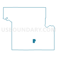
Cullen Voting District, Shawnee County, Kansas
About
Outline

Summary
| Unique Area Identifier | 587159 |
| Name | Cullen Voting District |
| County | Shawnee County |
| State | Kansas |
| Area (square miles) | 2.41 |
| Land Area (square miles) | 2.39 |
| Water Area (square miles) | 0.02 |
| % of Land Area | 99.11 |
| % of Water Area | 0.89 |
| Latitude of the Internal Point | 38.94613680 |
| Longtitude of the Internal Point | -95.71752330 |
Maps

Graphs
Select a template below for downloading or customizing gragh for Cullen Voting District, Shawnee County, Kansas


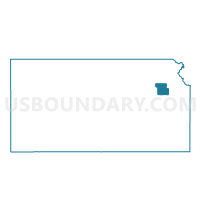
Neighbors
Neighoring Voting District (by Name) Neighboring Voting District on the Map
- Montara Voting District, Shawnee County, KS
- Pauline Voting District, Shawnee County, KS
- Topeka Ward 12 Precinct 12, Shawnee County, KS
- Wakrausa Voting District, Shawnee County, KS
- Washburn Precinct Mission Township Voting District, Shawnee County, KS
Top 10 Neighboring County Subdivision (by Population) Neighboring County Subdivision on the Map
- Topeka city, Shawnee County, KS (127,473)
- Mission township, Shawnee County, KS (9,365)
- Williamsport township, Shawnee County, KS (4,000)
- Topeka township, Shawnee County, KS (917)